Salt Creek in Death Valley National Park is one place that has water, and that’s usually only seasonally. I have never been there in summer, so I can’t say how dry it is then, but I imagine it’s pretty much dried up. Surprisingly, it serves as habitat for the critically endangered Salt Creek pupfish, which are about an inch long.
The narrow creek with its muddy banks is only part of the overall marsh area. The upper area holds small pools that remain year round, and where the fish can survive the summers.
On my fifth journey to the park earlier this year, I revisited Salt Creek, with the intention of spending more time, walking well beyond the boardwalk that parallels the creek.
The boardwalk, which is almost a mile long round trip, ends where the creek peters off and the land becomes more open and vegetated, and the path is sandy.
In late afternoon light, the sun highlighted the creek and magnified the textures and shapes in the mud.
With the sun getting lower and most visitors back in the distance, I drank in the gift of Death Valley, pure silence. I looked and listened for birds, but found none.
Nonetheless, the landscape was enough. I loved the way the low sun hit the water, and a variety of textures and shapes revealed themselves.
I knew some of my images would look best in black and white.
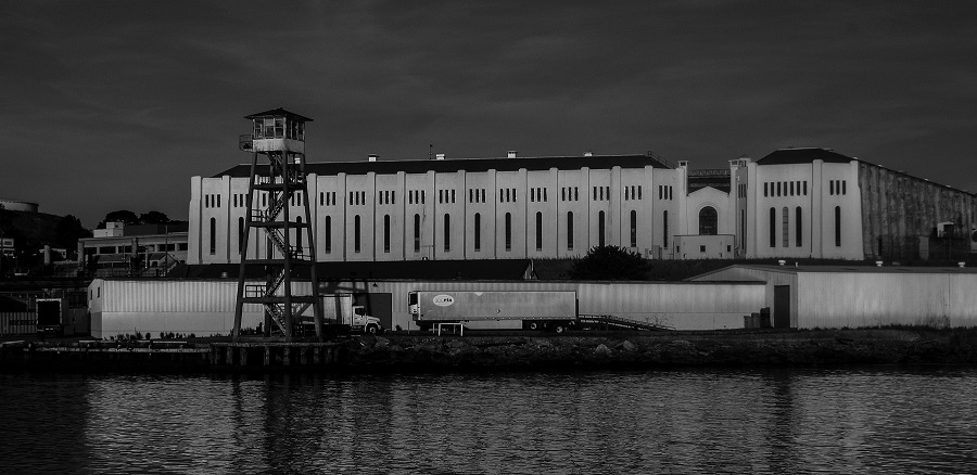
I got to see it recently while taking a ferry from Marin County to San Francisco. There it was, silently glowing gold in the late afternoon sun, with a guard tower nearby. Just a simple building at the edge of the water. There was no one outside that I could see. I had to imagine those inside.
With only water between us, I almost got a chill seeing San Quentin State Prison in real life. After all, it’s the stuff of 1940s black and white movies, in which gangsters get their due in the end. I immediately had a vision of Humphrey Bogart, dressed in shades of gray, with his classic sneer and heavy five o’clock shadow.
Among those sent there are all men who have received the death sentence in California. There have been executions in the past, but none have taken place since 2006. In 2019, the governor ordered a moratorium on executions. Almost 700 men remain on “death row.”
The maximum security prison opened in 1852 and is the oldest in California. Pretty tough to escape from there, eh? Some have tried, but no one has ever successfully fled the prison.
Oddly, the tough prison has served as a setting for numerous films and concerts. Johnny Cash performed for prisoners twice, once with inmate Merle Haggard in the audience. B.B. King and Metallica later performed there.
Bogart was indeed tied to San Quentin: he played an escapee in the 1947 film “Dark Passage.” Several other movies used the facility, including Woody Allen’s “Take the Money and Run.”
The prison has evolved somewhat since it opened. There are now programs to rehabilitate prisoners who are able to be released, and they do have access to exercise, education and entertainment. But for me, San Quentin will always be that cold, concrete place swathed in black and white, where the baddest of the bad simmer inside.
There’s an ad jingle in my memory cells that goes something like this, “Who put eight great tomatoes in that little bitty can? You know who, you know who, who, who.” For some reason, the word Sacramento sticks in my mind along with it.
When I was in the Sacramento, California, area recently, I learned that tomatoes are a huge crop there. A lovely painted vintage-style sign at the tomato processing plant in Woodland verifies that fact.
Surrounding Woodland are farm fields as far as the eye can see. No doubt many of those perfectly aligned rows get planted with the red fruits every year.
California grows 95 percent of the more than 12 million tons of tomatoes produced in the U.S. Those fruits come to our tables as fresh tomatoes, canned, paste, sauces, juice and ketchup. The state’s Central Valley is the heart of tomato country. The tomatoes are processed – cooked, crushed, diced, canned, etc., right there in the Central Valley.
The plant I saw in Woodland is among the few processors left in California.
Statistics I found from 2008 show that there were 225 tomato growers in the Central Valley, farming some 277,000 acres, and working with 16 commercial canneries.
But, in case you didn’t know, the tomato is not native to North America. It is said to have originated in South and Central America. It made its way over to Europe in the 1500s. Not surprisingly, Italians were the first to start growing and eating them. Not too long after that, other countries began growing them, but only as items of curiosity. Using them for food had not really caught on yet.
It wasn’t until the 1700s that tomatoes started to be grown in the young United States. Farmer-gardener that he was, Thomas Jefferson naturally took to growing them. But there was still widespread belief that they were poisonous, as members of the nightshade family.
Now we know better. Tomatoes, which are mostly water with a little bit of fiber, are highly nutritious, providing vitamin C, potassium, vitamin K1, lycopene, and beta carotene, among others. And, how about they are just plain delicious! Who doesn’t love a fresh tomato sandwich? Where would pasta be without sauce?
But even as bountiful as the tomato crop appears, and as endless as our appetites are for tomato products, it remains a risky and costly commodity to produce. Tomatoes like sun and heat, but not too much. California is known for a long growing season, but also for a lack of water. Fuel to power mechanical harvesters, fertilizer and water eat into any farmer’s profits. Throw in unpredictable weather.
Thankfully, we now have small and organic farms growing heirloom tomatoes in almost any state that we can buy locally and at our farmers’ markets. We don’t have to depend on big footprint, long-distance crops, at least part of the year. I, along with millions of other Americans, plant my own in my frontyard garden every year.
Each season is an exciting unknown: which varieties will I try? Which ones will taste best? I know that plants sold locally will do fine in my zone. My favorites have been Black Krim and Green Zebras, but I always aim to pick at least one new one to try.
Once thought to be poisonous, tomatoes are beloved and devoured by the tons. The perfect tangy, juicy tomato is the Holy Grail of our summer gardens. Let’s hope that no matter how our climate evolves, we’ll always have tomatoes.
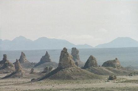
If Trona Pinnacles looks like something out of a sci-fi flick, that’s because it has indeed served as a backdrop for several movies. You might have heard of some of these: Star Wars, Star Trek V, Battlestar Galactica, Planet of the Apes.
First Impressions
I first drove to the Pinnacles in 2005, during a visit to Death Valley National Park. I had set aside part of one day to make the drive to the somewhat remote area managed by the Bureau of Land Management. But it took more than an hour to get there, and I had made arrangements for an afternoon horseback ride at Furnace Creek, back in Death Valley. By the time I got to the Pinnacles, I had about a half hour to spend there if I wanted to make my ride. I peered at the Pinnacles from a plateau that overlooked what I thought was a rather limited formation. There was a steep-looking road down to the Pinnacles, but I “there’s no way I’m driving down there,” I decided. I quickly snapped some photos from the parking area and sped back to Furnace Creek.
First visit
There would be a return trip in my future.
A Closer Look
It wasn’t until January 2017 that I made it back to Trona. I had planned to spend unlimited time there, doing lots of photography and some hiking. I lucked out with a dry day. This time I had rented an SUV, so I had high clearance, though a car could make it.
I drove south through Trona, and spotted the Pinnacles, rising like the Emerald City out of the desert. I arrived at the turnoff for the Pinnacles about 10 miles later. At the corner there are some interpretive signs about the human and geological history of the area.
I lingered there, reading and then taking some photos of the landscape and trains resting on the tracks. There were some cool cloud formations that also caught my eye.
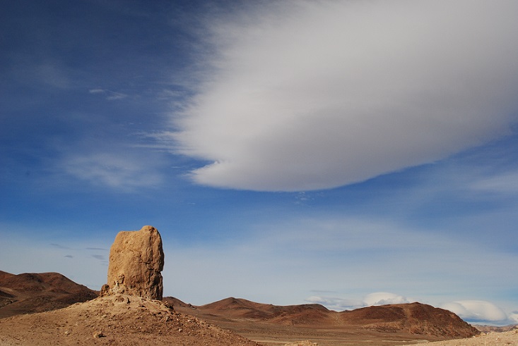
Lenticular
Spaceships landing?
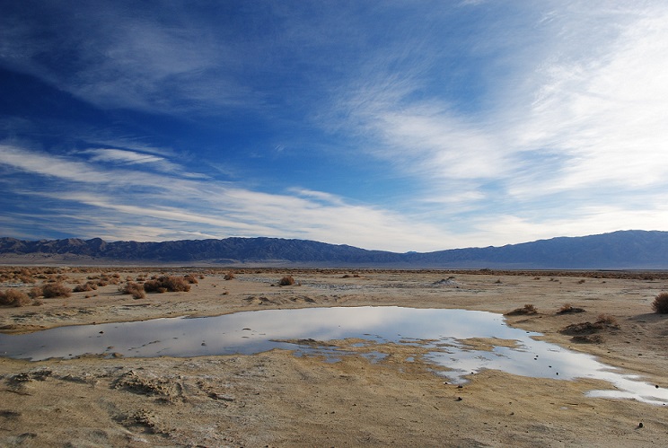
Rain pond
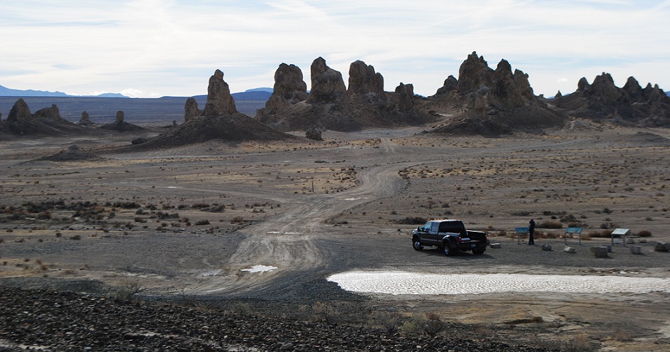
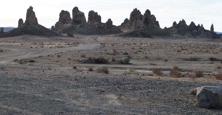
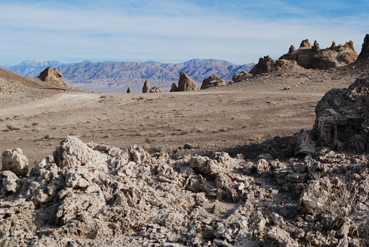
The five-mile dirt road to the landmark had received recent rains, so it wasn’t as sandy as I remembered. When I arrived at the plateau that overlooks the monument, I realized the drive down the hill to the Pinnacles didn’t look so bad, and saw other vehicles, including a huge RV, down below. How the heck did that RV make it down the steep drive, I wondered. You have to realize that the Pinnacles lie in a basin. To really experience them, you need to get down there. The drive down the gravelly slope was so easy, I felt silly.
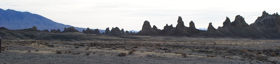
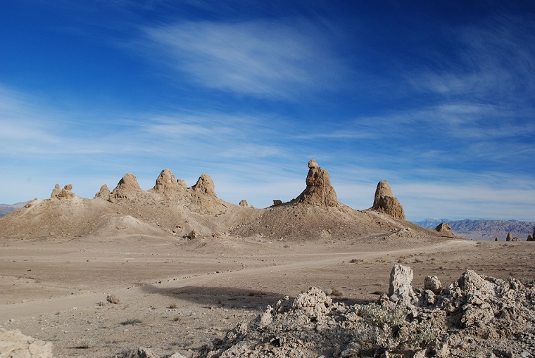
And then, I had my real surprise! Trona Pinnacles is expansive! You can’t even see all of it from the plateau. Narrow dirt paths snake around more than 500 formations. I had no idea how much I missed on my previous visit.
Towers and Dumpy Cones
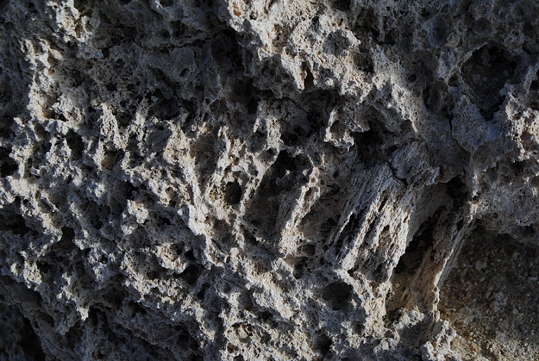
Like their cousins at Mono Lake, the pinnacles are tufa formations, which are primarily calcium carbonate.
Close up of tufa
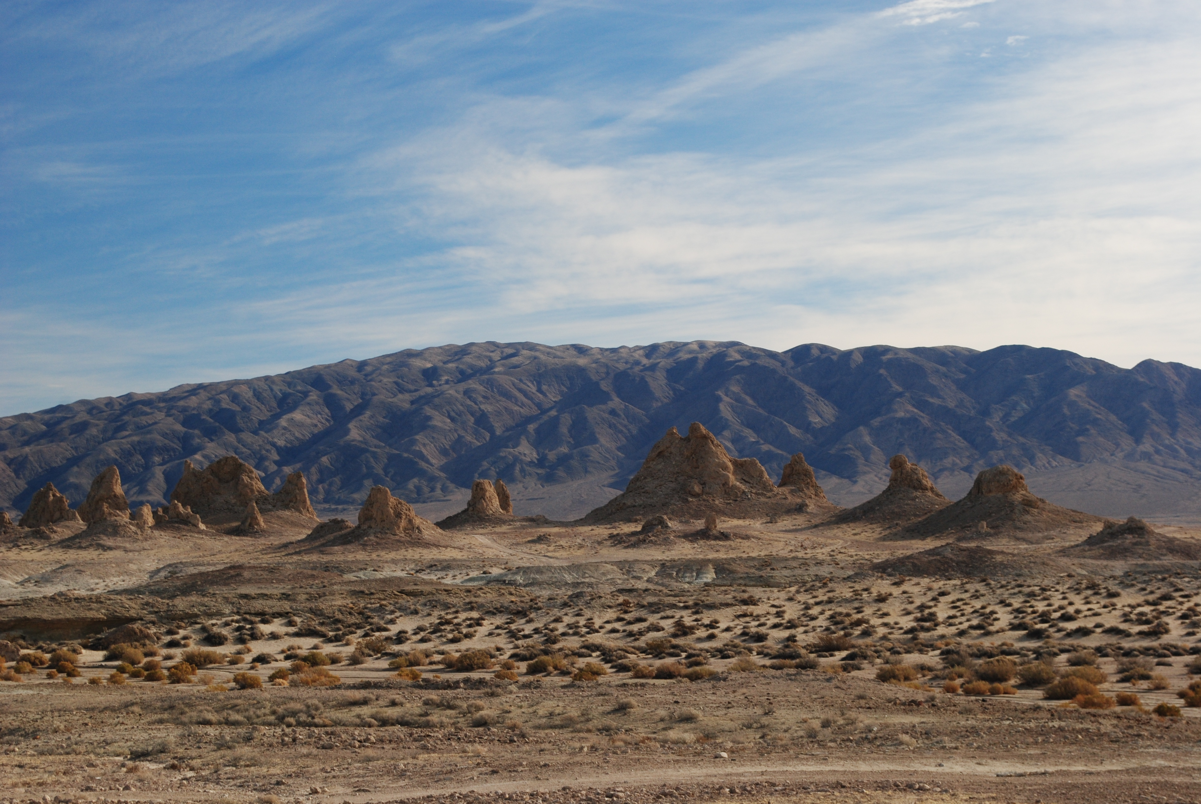
At Trona, they’re distinguished by age, elevation and shape. The northern, middle and southern groups were formed by different ice ages.
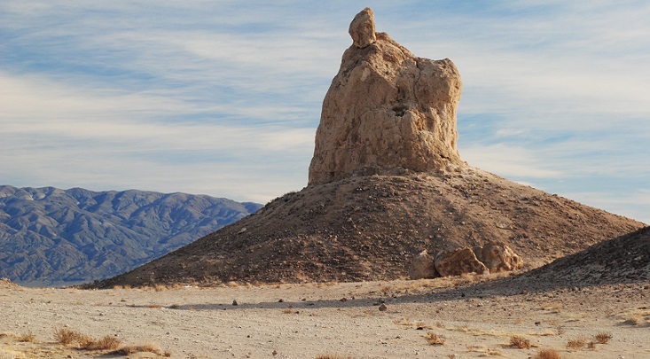
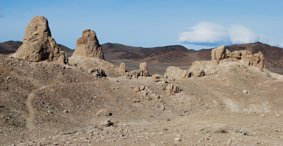
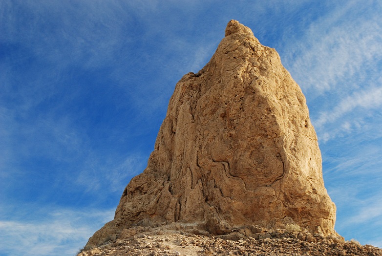
The shapes range from towers and tombstones, to ridges and cones. Towers are the tallest, rising 30-40 feet, while tombstones are “stubby and squat,” rising 20-30 feet.
Ridges are “massive, toothy runs” that can be seen in the northern and middle groups.
Finally, cones are the smallest, reaching only about 10 feet high, and they are “dumpy and mounded.”
On my visit, I concentrated on the tallest and most interesting formations, which turned out to be among the northern and middle groups.
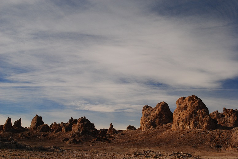
The sun was out; there were some spectacular clouds to add depth to the scenes. The only problem was the WIND. This was my fourth trip to Death Valley and never before had I experienced such winds. I was not going to abandon my photography plans, so I soldiered on.
Each time I got out of the car, I had to fight hurricane-like gusts. I was afraid the wind would snap off the car door! I had to use all my strength to close the door. It goes without saying that any hiking was out of the question.
During my visit, I saw only a couple other cars, and I suspect it’s not heavily visited.
A Wealth of Minerals
You can spend as much time as you like at Trona Pinnacles. It’s fairly easy to access, unfenced and free of fees.
Don’t expect much from the town of Trona, beyond a convenience store and gas, if you need it. With a population of about 1,900, it’s a sad little “blink and you miss it” hamlet that is centered on the mining activity in dry Lake Searles. The name of the town comes from the abundant mineral trona, one of many extracted by Searles Valley Minerals. Lake Searles once held water, eons ago, but as it slowly evaporated, the water left behind many minerals. In the 1800s, the dry lake became the scene of many mining operations. First, there was borax, famously being carted out by 20-mule teams. Later there was an Epsom salt operation, and now, a multitude of minerals is produced, including salt, borax, boric acid, and halite.
The natural landmark lies in Searles Valley, just south of Panamint Valley, and isn’t far from Naval Air Warfare Center China Lake. It’s also within the California Desert National Conservation Area.
It lies in a wind-battered, parched landscape, just north of Lone Pine, California, surrounded by spectacular mountain scenery and endless sky. In winter, bitter cold, snowstorms and wind were its inhabitants’ constant companions. In summer, searing sun, heat, wind and dust storms prevailed.
Manzanar War Relocation Center was one of 10 “internment camps” set up by the U.S. government to sequester and control Japanese Americans during World War II.
After Japan attacked Pearl Harbor, Americans began to fear and mistrust Japanese Americans, so 110,000 citizens and resident aliens from the west coast were forced from their homes and taken to these camps. From 1942-1945, the camps operated in remote, harsh landscapes.
Of those rounded up for the camps, 10,000 found Manzanar their new home. They thought their stay would be short. They were told that they were “not prisoners,” and that they were being isolated for their own protection. But when the Japanese arrived at the camps, they noticed that the eight guard towers were facing in, not out.
Military Style
Located in Owens Valley, the 500-acre Manzanar camp was built in an area that had been a rich apple-growing area, thanks to irrigation. There had also been pear and peach orchards. By the 1930s though, most farmers had moved out of Manzanar, and the city of Los Angeles owned the land.
The camp consisted of 504 barracks, organized in 36 “blocks.” Each block had 14 barracks whose population totaled 200-400 men, women and children.
Although the camp was ringed by picturesque mountains, it was no vacation paradise.
Barbed wire fences surrounded the drafty wooden barracks that would become their homes. Wind and dust blew through cracks. “Any combination of eight individuals was allotted a 20-by-25-foot room. An oil stove, a single hanging light bulb, cots, blankets, and mattresses filled with straw were the only furnishings provided,” explains the National Park Service, which manages the site. Privacy was nonexistent. Shared latrines had no walls, showers had no stalls.
The Japanese Americans struggled to retain their dignity. Their entire lives had been turned upside down. They lost their businesses and homes. They could bring only a few personal possessions with them.
Indomitable Human Spirit
But as the months went by, the community evolved. After all, thousands of adults brought their professional skills with them. There were teachers, doctors, nurses, artists, writers, craftsmen. School classes were formed. There was art and music. There were dances. They started a camp newspaper, the Manzanar Free Press. They operated a bank, beauty parlor and barbershop. They made clothes and furniture, and managed farm animals and food crops.
As you can imagine, with 10,000 residents, these services and activities were a necessity of survival, and internees were paid for their work. Some worked in the mess halls, while others served as police and firefighters. There was also a camp hospital, and a cemetery.
Site of a former camp “park.”
Gardeners found outlets for their passion by carving places out of the desert where people could find solace in nature. The internees were allowed to build ponds and gardens, and camp administrators even obtained materials for the construction. Gardens reflected the Japanese aesthetic, complete with waterfalls, rocks and bridges. These were spaces of hope and resistance.
No Japanese Americans were ever charged with espionage, and some of the internees even had sons serving in the war.
The Visitor Experience
Today, there is not much left of the camp except the preserved landscape, still cordoned by barbed wire. The original entrance survives, and small signs mark the rows where barracks stood.
Remnants of orchards can still be seen, in addition to excavated garden areas.
Two reconstructed barracks and a mess hall exhibit are part of a walking or driving tour you can do. A reconstructed guard tower, with its spotlight, overlooks the area.
At the end of the tour, you will find the cemetery. It’s the real thing, not a reconstruction, with real graves and origami garlands left by visitors.
A visitor center has impressive exhibits of daily life of the internees, and a must-see award-winning short film that is so well done, it will bring tears to your eyes. And no doubt while you are there, you will experience a taste of the ever-present winds.